
Last updated: March 23, 2018
Hi and welcome on this page! Here, you can download the source files behind reconstructions of active margin deformation zones that I have published with my colleagues over the last years. If you use these files, please give reference to the proper publications, as detailed below.
My reconstructions are made with GPlates free software, and are embedded in the global plate kinematic reconstruction of Seton et al., 2012 that is the default reconstruction in GPlates.
GPlates works with two types of files: a shape file that defines the polygons, or lines that are reconstructed through time (.gpml format), and rotation files that define how those polygons or lines move relative to each other through time, as well as an absolute reference frame that shows how the entire plate reconstruction is positioned relative to the mantle (mantle reference frames) or the Earth’s spin axis (paleomagnetic reference frames). Relative and absolute motions are described in a .rot file.
Here, you can download my published reconstructions: (click here for a zip file with all files).
Shape and Rotation files
I provide three folders with files: Shape files, rotation files, and reference frames. The shape files can be uploaded in GPlates, and comprise:
A set of modified files from the reconstruction of Seton et al. (2012) whereby I updated the Pacific ocean reconstruction following Wright et al. (2016), and deleted the polygons in areas that I have reconstructed in more detail. These modified files are:
Basis_Polygons_Seton12_Wright16.gpml
Coastlines_Seton_etal_2012.gpml
Fracture_zones_Seton_etal_2012.gpml
Our own files include:
see: van Hinsbergen et al., 2011; 2018; Gaina et al., 2015;
Iran.gpml (work in progress, this is only a very first attempt)
McQuarrie and van Hinsbergen, 2013
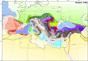
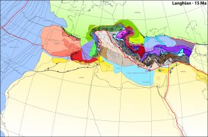
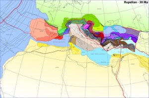
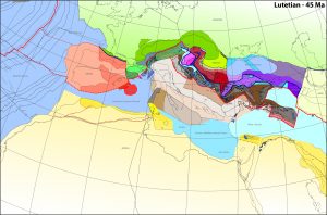
Mediterranean.gpml
see: van Hinsbergen and Schmid, 2012; van Hinsbergen et al., 2014; van Hinsbergen et al., 2019a
Caribbean.gpml
see: Boschman et al., 2014 and Molina-Garza et al., 2018
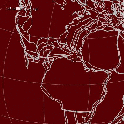
Andes.gpml
see: Schepers et al., 2017
Basin_range.gpml
I made a GPlates rendition of the beautiful reconstruction of McQuarrie and Wernicke (2005) of the Basin and Range province since 36 Ma, published as part of Boschman et al., 2018.
SW_Pacific.gpml
see: van de Lagemaat et al., 2018
NW_Pacific.gpml
see: Vaes et al., 2019
Oman.gpml
see: van Hinsbergen et al., 2019b
Rotation file
My ‘master’ rotation file is based on the rotation file of Seton et al. (2012), updated with the updated Pacific reconstruction of Wright et al., 2016 and follows their rotations for the major continents:
190701_vanHinsbergen_master.rot
To this file, you can should the rotation files that come with the reconstructions per area:
India_Arabia_Asia.rot (codes 4000-4100 and 7000-7400)
Mediterranean.rot (codes 3000). This file includes rotations for the Aegean and SW Mediterranean region, as well as a full Mediterranean reconstruction that I hope to publish in 2019
Caribbean.rot (codes 2000-2250)
Andes.rot (codes 2500-2750)
Basin_Range.rot (codes 10000-11500)
Absolute Reference frames
Finally, to the rotation file, you should add a reference frame (701 to 0). In the zip file, there are several of these frames available. Mantle reference frames should be used for geodynamic problems, paleomagnetic reference frames for paleogeography and paleoclimate studies (see van Hinsbergen et al., 2015 and Paleolatitude.org for an overview.
mantle reference frames:
Frame_vanderMeer2010slabframe.rot for the slab reference frame of van der Meer et al. (2010) (my default)
Frame_Doubrovine2012hotspotframe.rot for the global moving hotspot reference frame of Doubrovine et al. (2012)
Frame_O’Neill2005hotspotframe.rot for the Indo-Atlantic moving hotspot reference frame of O’Neill et al. (2005) (GPlates default)
Frame_Torsvik08GMHFsmoothed.rot for the Indo-Atlantic moving hotspot reference frame of Torsvik et al., 2008
Frame_Torsvik2012pmagTPWcorrframe.rot for the true polar wander corrected paleomagnetic reference frame of Torsvik et al. (2012) (NB, no paleolongitude control!)
paleomagnetic reference frames:
Frame_Torsvik2012pmagframe.rot for the paleomagnetic reference frame of Torsvik et al. (2012) (my default)
Frame_BesseCourtillot2002pmagframe.rot for the paleomagnetic reference frame of Besse and Courtillot (2002)
Frame_KentIrving2010pmagframe.rot for the paleomagnetic reference frame of Kent and Irving (2010)
Movies
In addition to the reconstruction files listed above, I have made a few movies that can be used for teaching or outreach purposes and that you may find useful:
India-Arabia-Asia movie
Caribbean movie
Mediterranean movie
Aegean movie
Western Mediterranean movie
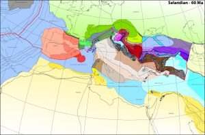
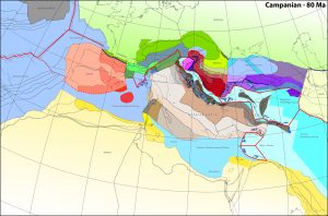
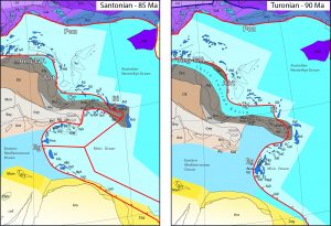
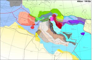
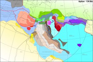
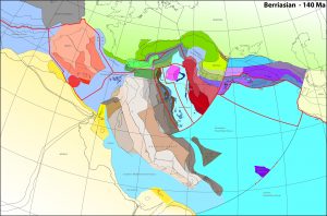
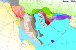
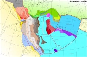
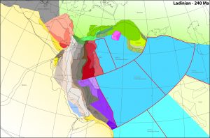
Mediterranean paleogeographic maps
Click on image to download an A1 pdf-version of the map. Maps published in van Hinsbergen et al., 2019a
Global tomography and subduction zone reconstructions
Over the last years, we have published several papers on a compilation of lower mantle slab remnants, and used this to develop mantle reference frames (van der Meer et al. 2010), improve oceanic plate reconstructions (van der Meer et al., 2012), and quantitatively assess the influence of geodynamic processes on climate evolution (van der Meer et al., 2014). Much of this information is now included in the Atlas of the Underworld, but GIS files that lay at the basis for the previous papers can be downloaded here: